Ground Engineering offers a comprehensive range of professional services to complement its ground investigation capabilities. Our professional services include:
CASE STUDIES
Subsidence Case Study
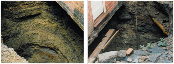
A large hole opened up overnight in the rear yard of a mid-terrace property in the Spinney Hills area of Leicester. The house was originally built around 1900, with an extension added more recently. The 4.50m diameter, cylindrical straight sided hole led to a claim for subsidence damage. Ground Engineering was appointed by the Loss Adjuster acting on behalf of the householders Insurance Company, to advise on the situation and provide guidance and a solution to the problem. An investigation, including historical and mining desk study and physical investigation was undertaken to provide information on the ground both inside and outside the area of collapse, in order to establish the reason for the collapse and allow remedial measures to be formulated.
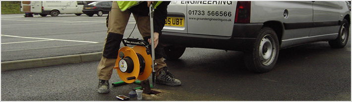
Initially, the crater was filled and a stable drilling platform constructed to enable a restricted access cable percussive boring rig to sink a 30m borehole through the centre of the area. Similar boreholes were sunk adjacent but outside the area of collapse.
The investigation confirmed that the collapse had resulted from a former coal prospecting shaft dating to the late 1700s. The investigation found several baulks of timber, some of which were rotten and believed to represent the former capping structure to the shaft.
Since the considerable depth of fill material contained a void ratio of 20%, grouting was ruled out based on the substantial amount of grout required. Ground Engineering recommended a remedial solution of a capping structure supported by the competent Mercia Mudstone surrounding the shaft to support the property and adjacent house.

Slope Stability Case Study
Further development of an existing business park in Grantham, Lincolnshire was proposed. Ground Engineering was appointed to investigate the likely effects of the proposed further development on the stability of the existing slopes.
During the initial assessment, it became evident that not only would remedial measures be required on the main slope for the proposed development, but also that two other existing slopes were in danger of collapse. Subsequent investigation revealed that several different causes of instability were in action and the suggested remedial measures were designed accordingly.
The site was on the northern flank of the Lincolnshire Edge (limestone hills), which rise some 60m above the valley floor beneath. The site comprised a 300m long, 50m width of slope with an elevation difference of some 14m. The site was underlain by impermeable units of the Whitby Mudstone Formation capped, further upslope, by the permeable Inferior Oolite Group: resulting in a spring-line within the site. Several studies, by Chandler, of the Whitby Mudstone Formation in this area of England show that this unit will generally only sustain an ultimate angle of slope stability of approximately 9º and rarely above 10½º. The general angle of the main slope was around 9º, although development during the 1930’s, including an access road that had been built upon an embankment, resulted in localised over-steepening of the slope (to as much as 21º) and interference with the drainage off the slope. This slope had subsequently been planted with trees, many of which displayed twisted trunks: characteristic of growth on a moving slope.
One end of the main slope had been subjected to clay extraction for brick making. The extraction removed clay to a depth in excess of 10m (at the highest end of the site) and continued until around 1965, after which it had been backfilled in an apparently uncontrolled manner.
There were further problems, with two smaller slopes at the lower end of the site. The older of the two was 5.0m high by 14m wide (an angle of approximately 22º) by 120m long and was supported at its lower end by a 1.0m high concrete and brick retaining wall. This slope was displaying evidence of instability. Inspection of the retaining wall revealed some significant cracks and closer inspection showed that the weep-holes had not been maintained, or had even been completely blocked.
The second smaller slope angle was at an angle of 21º; was 3.0m high by 6m wide by 50m long, and was unsupported. This slope had been recently constructed, when a new car park was added by cutting, but it was already showing distress in the form of tension cracks at the crest.
The manner of investigation chosen was restricted by access problems on the steep and wooded slopes and the presence of overhead power transmission cables, supported on pylons. A series of cable percussion boreholes, DCS (driven continuous sampling) boreholes and trial pits was conducted and allowed in-situ strength testing and sampling for laboratory testing. The DCS rig proved useful in the slope stability investigation as it can access locations that larger rigs cannot. Installations were formed to monitor groundwater and four inclinometer pipes were installed to monitor ground movements, including one each on the two smaller slopes. The site works revealed shallow slickensided slip surfaces within the main slope, indicating the likelihood of previous localised rotational slope failure. Laboratory testing was conducted to derive undrained, peak drained and residual shear strength parameters.
Modelling of the slopes was conducted using Geo-Slope International’s software. This sophisticated package provides greater confidence in any derived factor-of-safety by allowing assessment of the validity of the chosen variables; automatic variation of the shape of the slip surface; and better modelling of slope reinforcement than previous programmes.
Inclinometers could not be installed on the main slope where the worst movements were occurring because of the access restrictions, but monitoring of the two inclinometers at other parts of the slope indicated only slight and gradual movements on these parts of the slope – confirming the evidence from the trees. Assessment of the stability of the main slope confirmed that previously-formed slip surfaces were being re-activated by the imposition of the estate road, embankment and compromised drainage. Various remediation options were considered; including soil nails and retaining wall with soil anchors, and a combination of re-profiling and construction of a retaining wall was recommended. Modelling of the necessary remedial measures to allow development above the former clay pit indicated that such a development would likely be uneconomic.
Monitoring of the inclinometers on the two smaller slopes confirmed the visual assessment that they were moving significantly. Modelling of the retained slope showed that the slope angle was inherently safe, but that the lack of maintenance of the weep holes was allowing a build-up of pore pressures behind the wall, causing progressive failure. The unsupported slope had been constructed at too-steep an angle for the soils within the slope to support. Remedial recommendations for both slopes included for reduction of the slope angle by widening - as well as for repair and maintenance of the existing retaining wall. Because of the inherent loss of amenity in that option, reinforcement by soil nailing (for both slopes) and construction of gravity-wall for the unsupported slope were also modelled.